Indiana Tornado Outbreak
Indiana Tornado Outbreak – 8/24/2016

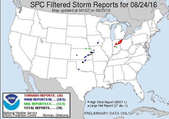
A State of Emergency has just been declared in Kokomo, Indiana after an EF3 tornado tore through the city. This tornado was part of a swarm of tornadoes that impacted the state and neighboring Ohio. Yesterday’s Indiana Tornado Outbreak spawned over 35 tornadoes. While tornado outbreaks are not uncommon to this part of the country, statistically spring is the most likely time for tornado outbreaks to occur.
However, it should be noted that tornadoes and ‘tornado outbreaks’ – defined by the Storm Prediction Center as a cluster of at least 6 tornadoes – can occur any time of year when conditions are favorable.
The Atmosphere Primed for an Outbreak:
“Hindcast is 20/20 (sort of, there’s still a lot we don’t know), but the tornado outbreak in Indiana and Ohio appears to have been a prime example of “Goldilocks parameters.” Everything was just right in magnitude when in relation to each other.” – Isaac Pato
Bulk Richardson number, shown here, is one of the few parameters that exemplifies this:

So what exactly is the Bulk Richardson Number, BRN?
Bulk Richardson Number “is a ratio of buoyancy to vertical shear: BRN = (MLCAPE) / 0.5 * (U)**2 where U = the wind speed difference between the density weighted 0-6 km mean wind and the lowest 500 m mean wind. The BRN is meant to estimate the balance between vertical shear and buoyancy, with low BRN values suggestive of vertical shear that is too strong relative to the buoyancy, and large BRN values are suggestive of multicell clusters. Intermediate BRN values favor sustained supercells.” http://www.spc.noaa.gov/exper/mesoanalysis/help/help_brn.html
Essentially, the BRN is a calculation for the amount of mid level CAPE or instability, in proportion to the strength of vertical wind shear. Too much shear, and too little CAPE, storms become outflow dominant, just the right amount of shear, and just the right amount of CAPE, A.KA. “goldilocks effect” and the storm is likely to be able to sustain its organization. A well organized supercell is the most common storm mode for the formation of tornadoes.
What other ingredients were “just right” for the Indiana Tornado Outbreak to occur? Coupled with just the “right amount of Instability” and the “right amount of shear” – the low level winds were in the most favorable position to enhance the storm’s rotation – this phenomenon is called helicity.
In technical terms, helicity is- “A property of a moving fluid which represents the potential for helical flow (i.e. flow which follows the pattern of a corkscrew) to evolve. Helicity is proportional to the strength of the flow, the amount of vertical wind shear, and the amount of turning in the flow (i.e. vorticity). Atmospheric helicity is computed from the vertical wind profile in the lower part of the atmosphere (usually from the surface up to 3 km), and is measured relative to storm motion. Higher values of helicity (generally, around 150 m2/s2 or more) favor the development of mid-level rotation (i.e. mesocyclones). Extreme values can exceed 600 m2/s2.”
The devastating Indiana Tornado Outbreak had over 200 m2/s2 of helicity to work with.

It just goes to show, tornadoes can and do happen whenever the conditions are right, regardless of the time of year.