Hurricane #IRMA
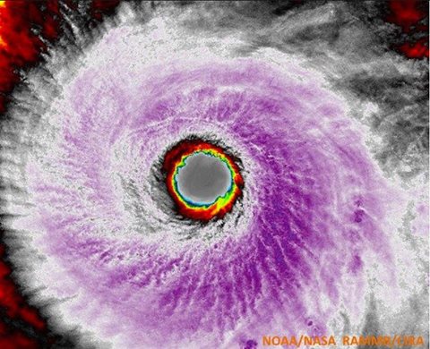
Hurricane Irma, a Category 5, is currently causing catastrophic damage in the Caribbean and making its violent trek towards the United States. False color satellite image of Irma yesterday evening indicate the strength of this very impressive storm! It is almost perfectly symmetrical. The symmetry of a hurricane can be used to estimate intensity, this is called the Dvorak technique. The more symmetrical, the stronger the storm and vice versa. Here is a link describing the Dvorak technique: http://www.aoml.noaa.gov/hrd/tcfaq/H1.html
The best site for the latest and most accurate forecasts for Irma come from the National Hurricane Center
According to the National Hurricane Center:
Low vertical wind shear and warm waters along the forecast track of
Irma should allow it to remain a very powerful hurricane during the
next several days, and the intensity forecast is again near the
upper-end of the guidance and is the same as the previous advisory
through 96 hours. Increasingly southwesterly shear and potential
land interaction late in the period is expected to cause some
decrease in Irma’s strength by day 5.
South Florida looks exceedingly likely to receive a significant portion of catastrophic hurricane winds, storm surge, and flooding this weekend.

Mandatory evacuations are already in effect for Monroe County in the Florida Keys, and zones A and B in Miami-Dade county. Here’s Miami Beach Police’s Tweet with the zone maps based on storm surge vulnerabilities:

Always heed evacuation warnings, and don’t feel you necessarily have to wait for an evacuation order to leave, if you can safely do so. Here is a current list of shelters open in Miami: http://miami.cbslocal.com/2017/09/06/four-shelters-open-miami-dade-irma/
Stay tuned & stay safe!