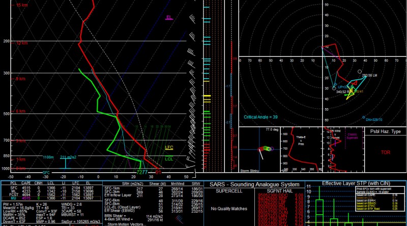
August 28, 1973 Canaan, NY – West Stockbridge, MA F4 Tornado Environment
As this is the second blog post, and at the time of writing this, the first post is not completed… I decided I would just share how I’m spending my Sunday night after suffering through a disappointing Patriots loss to the Dolphins.
I was reading about the unusual F5 tornado that devastated the town of Jarrell, TX on May 27, 1997. The tornado formed in an environment of strong deep-layer wind shear, extreme instability, and weak low-level flow. Its parent supercell back-built along a dryline resulting in a southwestward storm motion at 8kts… which is very rare for a violent tornado.

Anyway, a quick glance over an NWS webpage discussing this tornado motivated me to look up soundings from the event, and what better way to look at soundings than to use SHARPPy! Since ancient soundings are most readily available through the University of Wyoming, I wrote a quick excel spreadsheet to convert Wyoming’s format to SHARPPy’s format. You can download the spreadsheet here if you want, but it will take a bit of patience and tweaking to make it work right for every Wyoming sounding.
There’s an absolutely extreme amount of CAPE on that 5/28/1997 00z DRT sounding: 7196 J/kg of SBCAPE. Naturally, I wanted to use my new tool to view tornado proximity soundings with over 9000 CAPE, and Bangladesh is probably the most likely place to find that. I headed over to Jonathan Finch’s Bangladesh Tornadoes website and quickly found myself reading about EMLs.


Instead of finding a sounding with insane CAPE, a proximity sounding from an F4 tornado event along the NY/MA border caught my eye, and I needed to SHARPPy-fy it.

This would be a typical late-summer severe weather sounding for the region with modest upper-level flow, however, the strong EML around 850mb provided both steep mid-level lapse rates, and a capping inversion. These factors work to limit morning “crapvection,” and increase potential CAPE values due to diurnal heating. By 11am EDT, BDL in Windsor Locks, CT reported a T/Td of 91/72, totally eroding the cap and realizing MLCAPE values AOA 4000 J/kg. The F4 tornado formed in Canaan, NY at 11:34am EDT and moved south-southeastward across the MA border and into West Stockbridge, MA, predictably following the right moving storm motion depicted on the 12Z ALB sounding.
The tornado destroyed a truck stop and diner on MA-102 along the NY/MA border. Unfortunately the tornado killed 4 and injured 36. Since 1950, the return rate for violent (F/EF 4-5) tornadoes in Massachusetts is approximately 1 in 20 years.

The modified sounding on the right shows an extremely volatile environment for tornadic thunderstorm development. With 0-1km SRH in excess of 217 m² s⁻² it is no wonder that the violent tornado occurred.
-Isaac Pato

Hey guys, good luck with the website. Really enjoy the technical discussion and inclusion of sounding info. Me and a couple buddies are trying to start a small weather consulting firm and you guys are a bit of inspiration for us. Keep bein’ awesome!
Thanks Ben, much appreciated! Good luck, we’d definitely be interested in checking out your company’s website – keep us posted. We are really happy with how WordPress is working out for us.